Ireland is unique both in Europe and the world in terms of density of hedges on earthen banks as concluded by Muller (2013) https://wallhecke.de/en
While there is state/semi-state interest in calculating the carbon store potential of the hedge habitat zones in Ireland currently due to the Climate Change Crisis, the sustainable management of the resource in terms of monitoring biological diversity and cultural heritage conservation through ground sampling is not being fully realized.
A multi-disciplinary approach to an all island hedge inventory, in the context of producing credible statistics for inclusion in the tree cover components of the UN Land Use, Land-Use Change and Forestry (LULUCF) is necessary. Our Heritage Council supported project is intended to be a component which places the recording and monitoring of the structural and species diversity of hedge habitats into a more integrated inventory model along with other current Teagasc/ EPA initiatives focused largely on the carbon accounting aspects.
- Teagasc – Measuring and Mapping Hedges
- Teagasc – Enhancing soil carbon sequestration to contribute to carbon neutrality on Irish farms
Hedge Project Results so far:
Hedge plots of 500m2 are being compared with Forest plots of the same area, as a result of experimentation with the similarities and differences between the Hedgerow Appraisal System (HAS) and the National Forest Inventory ground sampling methodology (NFI). Polygon and Point file data are used to create shape files for field use. The accuracy of the images are then being tested initially on sites in Co. Leitrim.
- There are opportunities in cross-pollination between the HAS and the NFI methodologies, which combined with hand held technology could greatly increase the scope for compatible data sets to be produced and collated from each.
- Further refinement of a hybrid methodology will continue in the Spring/ Summer survey season.
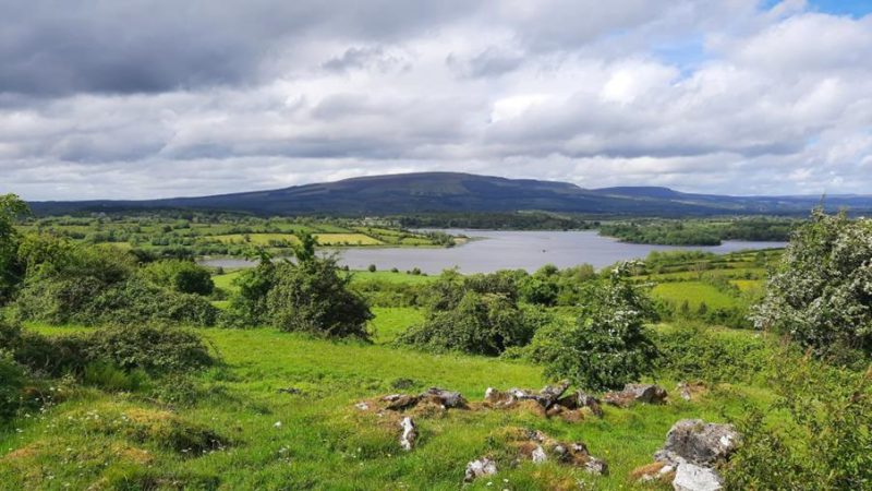
Landscape of tree cover including hedge and other wooded land plus forest as seen from Sheebeg, Co. Leitrim 2023
National Forest Inventory (DAFM) Proposal Submission (2024):
Carlow Hedgerow and Other Woodlands Project (2024 – 2026):
During the summer of 2025 field recording of hedgerows were carried out using a bespoke methodology based on the standard methodology of the Hedgerow Appraisal System of 95 hedgerows in two river catchments, the Burren and the Mountain. These samples were selected from 49 1km x 1km squares (40 in the Burren catchment and 9 in the Mountain catchment). The squares were identified on the basis of having at least 3 Very High Delivery Points for pollution impact based on Environmental Protection Agency Pollution Impact Potential mapping.